
The Top Station Ropeway: How Munnar's Tea Flew Down the Mountain
For more than half a century, the tea of the High Range left the hills hanging from a steel cable, swinging down a thousand-metre cliff from Top Station to the Tamil plains. The story of the ropeway that gave Top Station its name, what we know, what we don't, and what is left.
Stand at the edge of Top Station on a clear morning and the ground simply stops. Below your feet, the Western Ghats fall away in a sheer wall of rock, shola and grass, more than a thousand metres down to the green valley of Kottagudi and, beyond it, the hazy plains of Tamil Nadu around Bodinayakanur. Today the visitors who crowd the viewpoint come for the clouds. A century ago, people came here for a very different reason: this cliff edge was the gateway through which the tea of Munnar left the hills, and it went down on a wire.
The name "Top Station" is a fossil of that time. It was the top station of an aerial ropeway, the upper terminus of a line of steel cables that carried chests of tea down the mountain to a "Bottom Station" in the valley below.
At a glance
- Route: from Top Station, on the crest of the Ghats, down to Kotagudi (Kottagudi, the "Bottom Station") in the valley below, now in Theni district, Tamil Nadu.
- Length and drop: 13,320 ft (about 4.06 km) horizontally, rising 3,932 ft (about 1,200 m), at gradients as steep as 1 in 1.75.
- Built: surveyed from March 1898; opened for traffic in August 1900, by the Kanan Devan Hills Produce Company.
- Engineers: laid out by the company's chief engineer, Richard Fenwick Thorp, with its mechanical engineer, W. Kemlo, who designed and built the ropeway.
- Power: electric, from a small water-driven power station on the hillside: two Pelton wheels giving about 80 horsepower.
- Capacity: up to 20 tons each way in a ten-hour day; 5,500 tons were carried in 1903.
- Fate: wrecked by the Great Flood of 1924; ropeways continued to serve the High Range afterwards, the last reportedly until about 1969.
The problem of the cliff
In 1877 the Travancore state granted a syndicate a concession over the high ranges in the north-east of the state, and in 1895 the lands, nearly 200 square miles of them, passed to the Kanan Devan Hills Produce Company. By 1898 the company had more than 10,000 acres under tea, coffee and cinchona, and every month it had to bring in 300 to 400 tons of rice, stores and materials, and send its produce out.
The obstacle was the eastern wall of the Ghats. On the Madras side, the hills were, in the words of the company's engineer, "steep and precipitous". The lowest gap in the ridge stood at about 6,200 ft; the plains below, at about 1,100 ft. The only links were rough bridle paths. Goods from Bodinayakanur, at the foot of the hills, reached Munnar on the heads of porters, in loads of 56 lb, taking 12 to 14 hours, or on pack-bullocks over two days, at a cost of 35 to 50 rupees a ton.
In 1898, a new chief engineer, Richard Fenwick Thorp, set out a three-part solution:
- the Kotagudi Ropeway, about 2½ miles long, to lift goods up and lower produce down the cliff;
- the Kundale road and tramway, 22 miles long, from the top of the ropeway down the Kundala valley to Munnar, on Charles Ewing's single-rail (monorail) system, its trucks drawn by pairs of bullocks;
- the Bodi–Kotagudi road, a 10-mile cart road from the foot of the ropeway to Bodinayakanur and the roads of Madura district.
(Thorp's paper says the road and single-rail tramway were completed before the end of 1900; most later accounts date the monorail to 1902, perhaps because, as he notes, it was run on trial for a year before being adopted permanently. Read the history of Munnar and Kundala and its lost railway.)
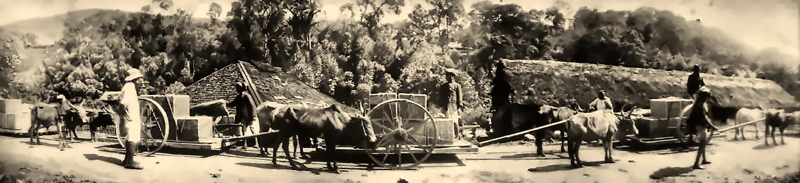
Building the ropeway, 1898–1900
Thorp chose and set out the line in partnership with the company's mechanical engineer, W. Kemlo. The survey began in March 1898. The ropeway runs dead straight from top to bottom, and it was split into two sections: a lower section of 7,563 ft and an upper section of 5,757 ft, meeting at a Central Station about 4,000 ft above sea level. There were two good reasons. Splitting the line cut the tension in the rope from its own weight, letting it carry more; and the staff could live at the Central Station "in a comparatively healthy climate", instead of at the bottom, in a valley so malarious that it was dreaded.
Everything had to be carried up by hand. The steel standards (towers) were made in the company's temporary workshop at Bodinayakanur and taken up the hill in pieces by porters. The rope came on drums, each holding about 4,000 ft, which were carried to the foot of the line, mounted on bearings, and the rope dragged up the rough and precipitous hillside, with great care to stop it kinking. The lengths were then spliced together, each splice 60 ft long, and lifted onto the standards: nine on the upper section and fifteen on the lower, between 10 and 35 ft high. A bridle track of some 5 miles was cut along the line.
The workforce came from the villages of the plains below: fitters, blacksmiths, carpenters and labourers, under three European assistants. Malaria took a heavy toll. On the road through the valley, Thorp records, as many as 150 workers were often down with fever at one time, "and many of them died"; after the first few months, no one would live in the valley, and the workers walked 10 to 12 miles each day to and from their villages.
The ropeway opened for traffic in August 1900.
How it worked
Kemlo chose the endless running-rope system, in which a single moving rope both carries the loads and hauls them, for its simplicity and low cost. The rope, less than 3 inches round, was made of 42 wires of best plough steel, with a breaking strength of 25 tons; in working, it was never stressed beyond 3 tons.
The loads were attached to the moving rope by automatic grips of Kemlo's own design. At each station, a hanger was hung on a shunt rail; when the load was slung on, hanger and load were run along the rail until the grip's jaws closed on the rope and the load set off down (or up) the line. At the far end, a small wheel on the grip ran onto the receiving rail, the jaws opened, and the load came off. Instead of buckets or boxes, the goods were simply slung from the hangers in rope slings, because so many different kinds of goods had to be carried. Loads were spaced 600 ft apart, could weigh up to 3 cwt (about 150 kg), and long items up to 20 ft could be carried between two hangers.
Despite the frightening gradient, Thorp notes that "very few accidents happen to the loads", provided the grips were carefully run onto the rope. The whole line was controlled from the Central Station by telephone.
The traffic ran in both directions. Going up: rice for the estates' workers, stores and building materials. Going down: the produce of the estates, chiefly tea, coffee and cinchona bark. On an ordinary day the ropeway carried about 180 loads of 1½ cwt up and the same weight down, about 15 tons each way; at full capacity it could manage 20 tons each way in a ten-hour day, running at 2, 3 or 4 miles an hour.
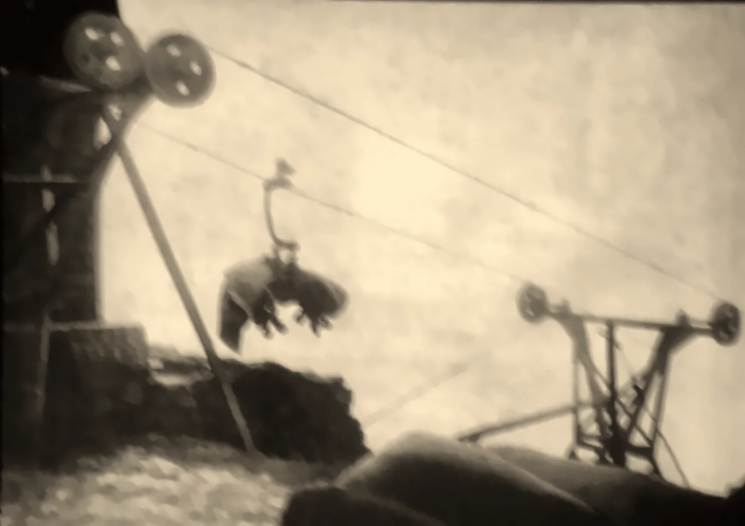
Hydroelectric power in 1900
Perhaps the most remarkable thing about the ropeway is how it was driven. Rather than steam, Kemlo used electricity generated by water. A small stream on the hillside was led along an open channel and iron spouting to a pipe, falling 720 ft onto two Pelton wheels, each 2 ft 6 in across and turning at 800 revolutions a minute. Together they developed about 80 horsepower, driving two dynamos of 40 amperes at 500 volts. Copper cables carried the current a little over a mile to two motors at the Central Station, which turned the ropeway's main drive through a hemp rope. The drums round which the steel rope ran were first lined with vengai wood, which wore out in five or six months; they were relined with harder ironwood, which lasted well.
Built in 1898–1900, this little power station is one of the earliest uses of hydroelectric power recorded in the hills of Kerala and Tamil Nadu, at about the same time as the company began to use water power at Pallivasal for its factories. (Read the Pallivasal story.) Some of the old spur wheels used on the ropeway were even bought second-hand from the Madras Government's Periyar project, the works that built the Mullaperiyar dam.
A new rope in 1903
The first rope went up in the spring of 1900. By early 1903, broken wires were running back and forming loops, and the company decided to replace it before the monsoon. This time, the engineers used the ropeway to install itself: the end of the new rope was clipped to the old, still-running rope with ordinary load-grips, and as it was paid out from drums at the bottom, more grips were attached at intervals, so that the new rope "made the ascent as a continuous load without any trouble or hitch of any kind". The old rope was then taken down and reused for repairing bridges on the company's roads.
Cost and savings
The ropeway cost about £8,300 to build, including the Pelton wheels, dynamos and telephones, and about £1,875 a year to run, including interest and depreciation. It was worked by a European engineer-in-charge and a staff of native fitters, clerks and labourers at the four stations. In 1903 it carried 5,500 tons, at about 5 rupees a ton.
The whole scheme, ropeway and both roads, cost 573,000 rupees (about £38,600). The company now charged 15 rupees a ton for transport by ropeway and tramway, against more than 35 rupees before: a saving, Thorp calculated, of about 110,000 rupees a year, or 19 per cent of the capital spent.
From Bottom Station to the plains
At the foot of the ropeway, the 10-mile Bodi–Kotagudi road, built by the company on behalf of the Madras Government and opened in August 1900, carried goods by cart to Bodinayakanur. Its upper six miles climbed the rocky gorge of the Kotagudi river, with cuttings up to 25 ft deep through solid rock and steel bridges built on site. The road was laid out to railway standards, because a light railway from Ammayanayakanur on the South Indian Railway to Bodinayakanur had been sanctioned, and it was hoped to extend it right to the bottom of the ropeway. From the railway, the tea went on to the ports and by ship to Britain.
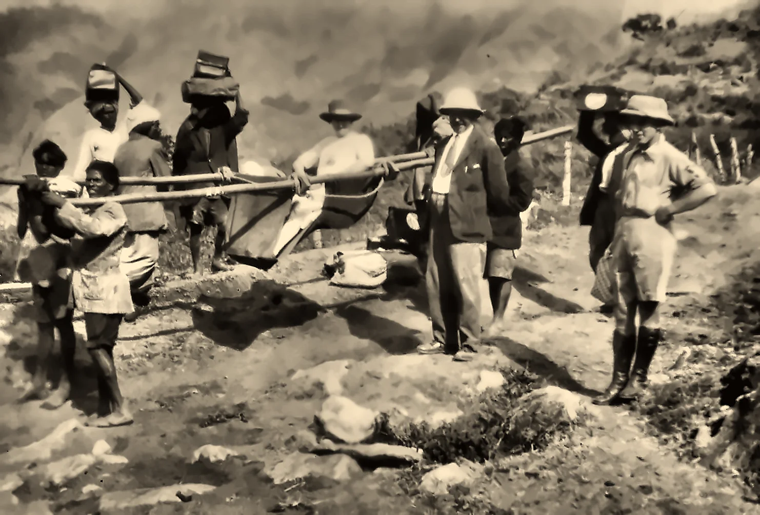
People, too, had to climb the escarpment. A photograph from 1921 shows planters being carried up from Bottom Station to Top Station by dhooli, a palanquin on poles, with porters bearing their luggage on their heads.
The flood of 1924, and the ropeways after
In July 1924, the Great Flood of '99 tore through the High Range. Landslides and torrents destroyed the Kundala Valley Railway, and accounts say the ropeway from Top Station to the lower station was destroyed with it. The railway was never rebuilt.
The hills did not give up on ropes, though. In the years after the flood, the company turned to a network of aerial ropeways to move tea and goods around the estates and out of the hills, alongside new roads: a dirt road was cut in 1925 from Top Station towards Kodaikanal, later famous as the Escape Road, and the Aluva–Munnar road opened the western route to Kochi. Photographs from the period show ropeway lines crossing the valleys around Pallivasal in 1929.
How long the ropeway at Top Station itself survived is not certain. A local researcher quoted by the Indian Railways Fan Club says an electric ropeway from Top Station down the slopes of the Pambadum Shola "functioned till 1969", and Munnar's own histories say an electric ropeway between Munnar and Top Station kept running until the late 1960s, by which time lorries on the improved roads had taken over. Whether these were the original line rebuilt, or new lines on a different alignment, is something we have not been able to confirm.
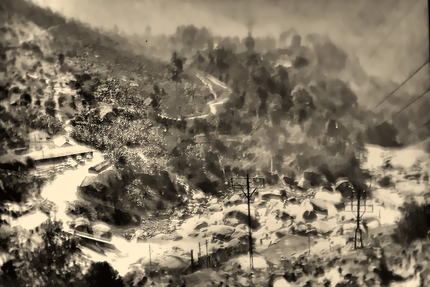
What remains
Little is left of the ropeway today, and almost nothing is signposted. At Top Station, visitors and trekkers have described the ruins of the old station buildings and a large platform near the viewpoint, and Kerala Tourism notes surviving wheels, tracks and a signboard. In Munnar, the old ropeway building is said to survive as a store. Along the trail down to the valley, walkers report occasional traces of the line, but most of the trestles and cables have long since vanished.
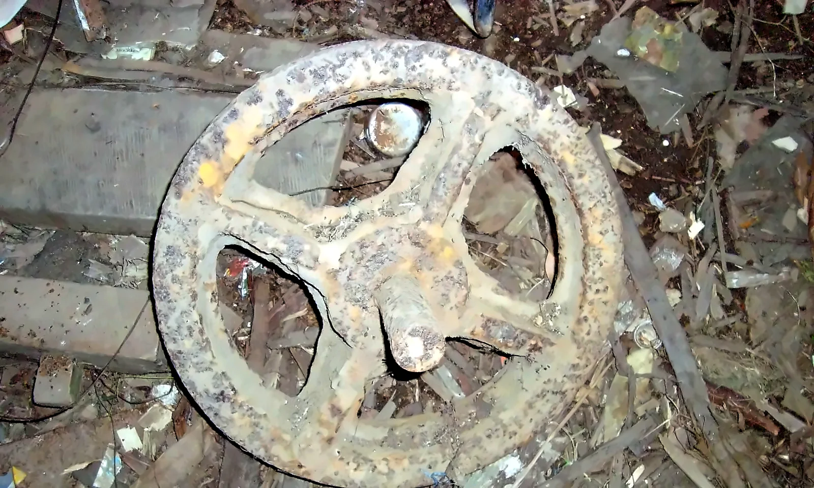
Following the line on foot
The old route of the ropeway is still followed by a footpath that climbs from Kurangani in the Kottagudi valley, through coffee and forest, past the hamlet of Muthuvakudi and the old Central Station, to Top Station: about 11 km and a climb of well over 1,000 m. It is a hard day's walk. In March 2018, a forest fire on the Kurangani hills trapped a group of trekkers and killed 23 people; since then, treks in the area have been regulated by the Tamil Nadu Forest Department and are allowed only with permission and authorised guides. (Read the Kurangani forest fire of 2018.)
Visiting Top Station
- Where: about 32–35 km from Munnar on the road past Mattupetty, Echo Point and Kundala. Top Station itself lies just inside Tamil Nadu (Theni district), though the only road to it runs through Kerala.
- Best time: early morning, before the clouds rise from the valley; September to March for the clearest views.
- Look for: the old station ruins near the viewpoint, and, on a clear day, the line of the valley the ropeway once spanned.
- Nearby: Kundala Lake, Echo Point, the Pampadum Shola and the farms of Vattavada. (See more restored photographs in Old Munnar in Photographs.)
A note on the evidence
- The construction and working of the ropeway up to 1904 are described here from the engineer's own account: R. F. Thorp, "Kotagudi Aerial Ropeway and Connecting Roads in North Travancore", Minutes of Proceedings of the Institution of Civil Engineers, vol. 161 (1905), Paper No. 3524. Quotations are from that paper.
- Its later history is less well documented. Accounts disagree on whether the line was rebuilt after the 1924 flood and on when the last ropeway closed; we have given what the sources say and flagged what we could not confirm.
- If you have photographs of the line, or family memories of it, please contact us.
Plan your Idukki journey with GK Global
Top Station is an easy addition to a trip through Idukki's high ranges. From our base in Adimali, the gateway to Munnar, GK Global runs Munnar jeep safaris, elephant-spotting drives and scenic day trips, and helps you find a stay to suit your plans. Our Top Station jeep safari follows the old road past Mattupetty, Echo Point and Kundala to the cliff edge where the ropeway began.
Explore our jeep safarisFind a staySee it for yourself, with a local driver who knows these roads.
Book a Munnar Jeep SafariSources & further reading
- R. F. Thorp (1905), Kotagudi Aerial Ropeway and Connecting Roads in North Travancore, Minutes of Proceedings of the ICE, vol. 161, via Zenodo
- IRFCA (2007): Mysteries of a Defunct Ropeway
- Wikipedia: Kodaikanal–Munnar Road
- Wikipedia: Kundala Valley Railway
- FIBIS wiki: Kundale Valley Light Railway
- Kerala Tourism: Kundala Valley Railway
- Onmanorama (2020): Once upon a railroad in Munnar
- Onmanorama (2024): Munnar's Escape Road
- The Sojourner from Bangalore (2017): Top Station trek
Figures are from the sources listed and were checked in October 2026. Park timings and road conditions change, so please confirm before you travel.